Tuesday, March 14, 2006
Paw Paw Bottom
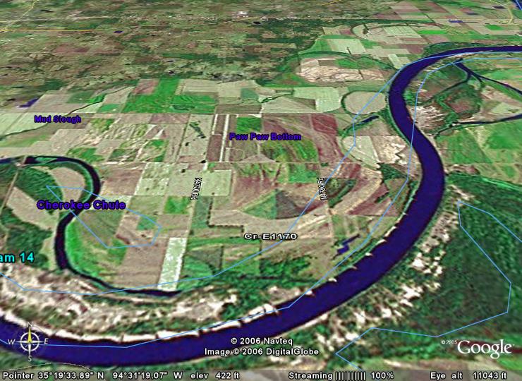
I am much obliged to Drlobojo for finding this image of Paw Paw.
See the words "Paw Paw Bottom" in the center of the picture, more north than south.
The crossroads just to the southwest is the "bottomless pond," a sinkhole, which is where my schoolbus stopped and turned around to head back out of the bottoms. Paw Paw being the terminus, it was called the Paw Paw Route.
The crossroads southeast of the words "Paw Paw Bottom" is where the Paw Paw School was; the townsite was here and to the east; just to the south is where the cemetery is.
--ER
Comments:
<< Home
This is a Google Earth Image from about 11,000 feet and on a 30 degree tilt. Google Earth is a free dowload and is really fun.
I like to position myself above a river or road at about 5,000 to 10,000 feet put the visual on a 45degree slant and use my mouse to litteraly fly down the river or road like I was in an air plane.
I like to position myself above a river or road at about 5,000 to 10,000 feet put the visual on a 45degree slant and use my mouse to litteraly fly down the river or road like I was in an air plane.
# posted by  : 10:05 AM
: 10:05 AM
You've quit? No matter.
Hey you can do it with George Dickle or Jack Daniels or B.J. Holliday as you co-pilot and not even need to worry about landing.
Hey you can do it with George Dickle or Jack Daniels or B.J. Holliday as you co-pilot and not even need to worry about landing.
# posted by : 11:39 AM
: 11:39 AM
I hoed watermelons in these bottoms the summer of 1980 for a farmer who lived at Cottonwood, which is about four or five miles to the northwest.
Daddy ER and his brothers farmed in the Moffett bottoms a few miles northeast of these bottoms.
Daddy ER and his brothers farmed in the Moffett bottoms a few miles northeast of these bottoms.

Well, I was going to say it was a beautiful picture, but now everyone will think I think bottoms are beautiful. And, I guess some are, but that's not the sentiment I was going for here...
I guess as the proper name of a geographical feature, it should be capitalized: Redland Bottom, Paw Paw Bottom, Moffett Bottom, Braden Bottom, and I guess Lee Creek Bottom? I also hoed watermelons up there around Lee Creek.
But I always heard it plural, and I was probably almost out of high school before I heard someone say "Moffett bottoms" or "Paw Paw bottoms." 'Cause Daddy ER and Mama ER always just talked about "the bottoms" -- and they meant Moffett.
But I always heard it plural, and I was probably almost out of high school before I heard someone say "Moffett bottoms" or "Paw Paw bottoms." 'Cause Daddy ER and Mama ER always just talked about "the bottoms" -- and they meant Moffett.
Drlobojo, if you click on the image and enlarge it, you can see light blue lines. I'm thinking that might indicate the natural watercourse of the river? The McClellan-Kerr Arkansas River Navigational System has tamed the ol' river and pretty much locked it in place.
My family, the John S. Higgins family lived in Paw Paw Bottoms back about 1910. I would be intersted in any information that anyone might have about them.
# posted by : 3:02 PM
: 3:02 PM
My ggfather was John S. Higgins. I don't know much about John, but I have all the info on his kids.
Dee
Post a Comment
Dee
<< Home
![]()

