Sunday, March 12, 2006
Ruins of Paw Paw, Okla.
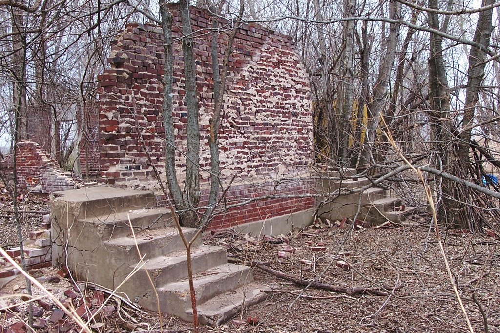
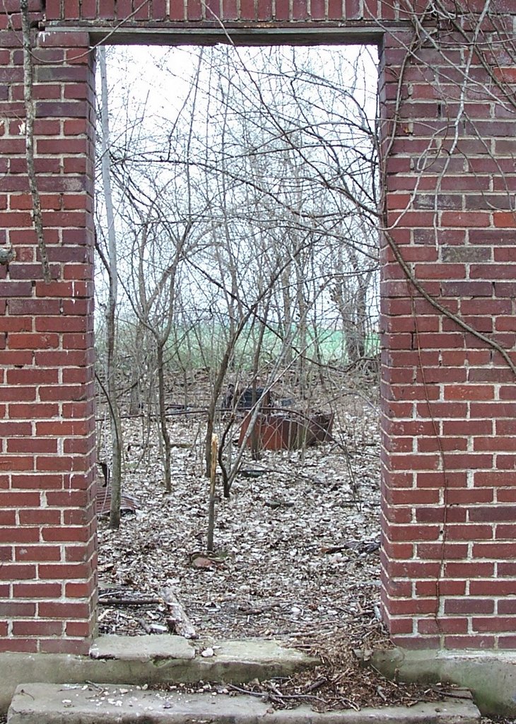
(Remains of the Paw Paw School, built in 1926. Six or seven miles south and east of Mama ER's house and ER's old stompin' grounds, in the Paw Paw bottoms of the Arkansas River.) --ER
By Louise Humphrey*
Paw Paw took its name from the Paw Paw Society**, a semisecret organization of Southern sympathy during the Civil War. Paw Paw trees were plentiful and many took for granted it was named for the trees. It is located in Sequoyah County, seven miles southeast of Muldrow on the Arkansas River.
The early settlement boasted a blacksmith shop and a general store with a post office in the back. Land was available if one wanted the task of clearing.
The owner of the general store was called Governor Watts, a large, heavy man, who claimed most of the land along the river. He created enough interest that a few families moved in and the community started to grow.
A cotton gin was built near the river, for cotton became an industry with the good rich soil. Steamboats came from Little Rock going as far as Muskogee carrying supplies, produce and passengers. Thus the settlement made progress until the accident.
At Fort Smith (Ark.) a railroad bridge crossed the river, with a span that opened to let the steamboat through. One day the bridge failed to open and the boat broke in half and sank. The old glamour of transporting by steamboat was never regained.
The progress of Paw Paw faced a real problem of transportation. A so-called road ran on the Paw Paw side of the river to Fort Smith, but the soil was not good for roadbeds. When wet, it was almost impassable. On the other side of the river, a fair, sandy and shorter road led to Fort Smith, but to cross the wide and swift river was a problem.

A ferry was established in 1880 so the farmers could get their produce to market in Fort Smith. After the passengers reached LeFlore County, they crossed another ferry across the Poteau river to get to the city.
The Paw Paw Ferry was operated by means of rope and a pulley attached to posts on either side of the river. The boat crossed at a forty-five degree angle so that the current did most of the work. Often the rope would break and carry the boat downriver into a sand bar. None was ever seriously hurt. Fare for crossing was 40 cents round trip for wagons, ten cents for horseback riders, and five cents for a footman. The ferry carried mail and newspapers and often transported cattle. Three wagons could be carried at one time on the boat.
Several pioneer families were Marion J. Watts, R.B. Patton, Sim Claborn, J.C. Cherry, S.J. Shackelford, W.R. Langford, Sim Eldridge and Lindsey Dickey.
The earliest school was a log cabin one-room building near the graveyard. Split logs were used for benches. R.B. Patton taught in the early school. “Neighbor Tom” Watts was also a stern teacher. Before the school was built, Dr. Bruton’s wife taught in their home.
Later a two-story pine timber school house was built. Thos. F. Watts taught over 100 children a day. The school term consisted of three summer months and four or five months in the fall. This corresponded with the crops to be made and harvested.
Later in 1926 a new brick school was built with four classrooms and a large auditorium with stage, office and storage rooms. The board members whose names appear in the cornerstone are J.Y. Kidd, R.L. Condren and O.W. Green. Dewey and Prudy Patton were early teachers when Paw Paw had a two-year high school.
Mr. Parker came in and built a store near the new school, a grist mill and blacksmith appeared, and a few bought lots and houses. As the community grew, roads improved and automobiles came, phonographs, player pianos, parties and marriages, and Dr. Collins was kept busy delivering children and controlling malaria fever, and was known as a specialist in curing pneumonia. During the flood he came to see that the families were placed in secure homes and even offered monetary assistance for food or whatever was needed for their welfare.
The first three cars in the community were owned by Ulphin Cherry, Sim Eldridge and Lindsey Dickey. These cars were tried out by making Sycamore hill in high gear. If they passed this test they were sold.
A “June rise” was prevalent from the river and it continued to dominate the outcome of the community. The water would go away and they would pile more dirt on the levee. In 1927 the levee broke and the old river showed its fury. When the flood alarm was spread people quickly left their homes for high ground. They watched the river build up to a width of about fourteen miles, and some watched their homes and livestock and life’s work go away.
The valuable $200 per acre land was sold for $9 per acre to settle accounts. The community continued to survive by farming, and sharecroppers farmed the land owned by Dr. Fox. Crops consisted of cotton and corn. During the depression very little money was made after paying rent, buying seed and a few staples.
Most of the food was raised on the farm. People were fortunate to be on a farm instead of in the city on a soup line. Home demonstration agents were helpful in the community with preserving food. On washday it was quite a treat to open a jar of canned meat and have lunch with very little preparation. As usual on the farm, food was plentiful when in season. When the cows freshened there was an abundance of milk, which was kept cooled in tubs of fresh pumped water. Later in hot summer weeks an iceman hauled ice from Fort Smith, providing ice for tea on the menu.
The early schoolhouse was also used as a community church. Different preachers of different faiths alternated each Sunday. The crowds were the same and the Union Sunday School literature was sufficient for all.
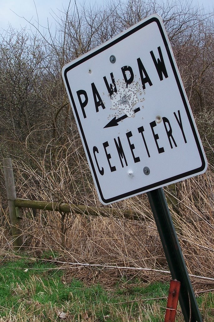
One of the main events of the year, besides Christmas, was Decoration Day. This fell on Mother’s Day. It was an all-day affair with preaching, decorating of graves, dinner on the ground, and a Mother’s Day program in the afternoon. This is still the custom but the programs are not as extensive, since all the families live elsewhere. During rehearsals in preparation for the program, you would hear of “decoration dresses,” “Sunday slippers” or “oxfords” being purchased new for the event. More often than not, the person in charge of the program was a school teacher who seemed to find “pieces” for all to recite.
This even taught the children respect for the dead. Flowers were gathered the day before in meadows and roadsides wherever wild flowers were available. Mrs. Hixson took children on a flat bed truck and picked the flowers. When the day arrived everyone came in their “finery” and carried a basket lunch. After the morning message by the preacher, the children were lined up “two by two.” The entire cemetery was decorated by the children, while the women were busy spreading the dinner on the ground. Tablecloths were laid on the ground and food was spread next to a neighbor or relative.
Everyone showed respect for their elders. It was not uncommon to call them “Uncle and Aunt” whether or not they were relatives. Some of these were Aunt Fanny Dickey, Aunt Nan Cherry, Uncle Tom Bailey, Aunt Jessie Shackelford, Uncle John Shackelford, Aunt Maggie Watts, Aunt Betty and Uncle Allen Blaylock, Uncle Will and Aunt Lillie Patton, Uncle Henry and Aunt Myrtle Shackelford.
The community continued to grow and the school doubled in size with two teachers in each room. This was made possible by bussing the children from Elm Grove and outlying areas of the Paw Paw school district. There were good ball teams and track meets where Paw Paw was able to compete with any school in the county. At one time a grade school girls’ basketball team coached by Clarence McDole defeated Sallisaw High School’s “B” team at a county tournament. But annexation caused the school to lose their attendance area.
The river never ceased to hold a threat over the community and in 1943 the old river showed its fury, complete, total, final. In its wake lay the death of a beautiful community.
There were other floods that covered the entire bottom. Today there are sink holes that stand on the landscape as mute evidence of terrible floods in years gone by.
Today the real danger of bad floods is past because of the controlled waters of the river through upper stream dams and the McClellan-Kerr Navigation System on the Arkansas River.
*From “The History of Sequoyah County 1828-1975”
Published in 1976 by The Sequoyah County Historical Society
ISBN: 0-938041-32-0
ARC Press of Cane Hill
13581 Tyree Mountain Road
Cane Hill, Arkansas, 72717
**I have found no clear evidence that this is true. Not saying it's untrue. The closest I can find in history is the Missouri Paw Paw Militia. More here. Maybe some of the original settlers of Paw Paw, who came from Arkansas, had moved there from Missouri. --ER
Comments:
<< Home
Wow. The Shackelfords, Kidds and Blaylocks are all cousins, and while I recognize some of the first names, I didn't realize they lived around Paw Paw. I have more ties to that particular piece of land than I realized. Very cool.

I think the center of gravity for white Sequoyah Countians is Paw Paw. It was the first real white, non Cherokee, nonChoctaw, nonmixed-heritage community in the county.
They were illegal settlers -- "intruders" -- actually. The Wattses were sort of like the Indian Territory version David Payne and the Boomers in Oklahoma Territory, always agitating for changes in U.S. and Cherokee law to allow them to settle in the Cherokee Nation. One of the Wattses ran an intruder-oriented paper in Muldrow. Muldrow, itself, was founded by intruders -- same as if a bunch of illegal Mexicans started a town on the U.S. side of the border.
They were illegal settlers -- "intruders" -- actually. The Wattses were sort of like the Indian Territory version David Payne and the Boomers in Oklahoma Territory, always agitating for changes in U.S. and Cherokee law to allow them to settle in the Cherokee Nation. One of the Wattses ran an intruder-oriented paper in Muldrow. Muldrow, itself, was founded by intruders -- same as if a bunch of illegal Mexicans started a town on the U.S. side of the border.
My Papa share cropped on Breedlove
Island. My nannie, aunts and uncles
went to school there.
Thanks, I feel like I got to go
home this weekend. I had sure
hoped to come see you but couldn't
get away..
Island. My nannie, aunts and uncles
went to school there.
Thanks, I feel like I got to go
home this weekend. I had sure
hoped to come see you but couldn't
get away..
ER said:
"...same as if a bunch of illegal Mexicans started a town on the U.S. side of the border."
That would be called Los Angeles last I remembered.
As for your Paw Paw Society; went through 8 search engines on the www and came up with the modern society devoted to the Cherimoya
Tree a.k.a. Paw Paw. Lot of sites about how to eat it; something in Chinese; something about dental hygene; nothing about any secret society.
Then finally there was this:
"At one end of the spectrum, the EMM included men whose Unionism was, at best, conditional. Some members enroleld under protest, promsing only to fight guerillas and not Confederate regulars. The so-called "Paw-paw" units of western and central Missouri were headed by Democrats, disarmed some Unionists, and were suspected of collaboration with the guerillas. However, the 28th EMM of Osage county had an entire "Reb company" of men with previous MSG or Confederate service; they, nonetheless, served the Union well against regular Confederates."
(found at: http://www.geocities.com/CollegePark/Quad/6460/CW/EMM/EMMhist.html)
And this:
"....This was at Clarksville, AR. They only lived there a short time and moved to my mother's country, to a place in the Arkansas River bottoms, now known as Paw Paw, which took its name from the plentiful crop of Paw Paw fruit bourn so profusely and where are some of the best farms in Oklahoma. Then it was a mere wilderness of cane breaker and wild beasts. Only one wagon road traversed from Cain Hill, AR and Wilson's Ferry which road was made by my step grandfather, Judge William Wilson, who married my widowed grandmother, Malinda (Wharton) Chisholm and lived at the Rock, and owned and operated the ferry."
found at:(http://www.zianet.com/blove/Our%20Breedlove%20Heritage/Carrie.html)
As for a Secret Society you may have stumbled upon a virgin historical subject for you newspaper research.
# posted by  : 1:01 PM
: 1:01 PM
Drlobo, I've seen those references, of course, since I've been thinking how to prove up the Rebel connection for years. ... I do need to scour some newspapers. ...
Jeanie, my brudder and I were in a part of the Paw Paw bopttoms Sunday morning that I hadn't been in for 15 years at least, maybe longer. South of the bottomless pond, toward the damn and Wilson's Rock.
Sooooo, "In 1927 the levee broke and the old river showed its fury. When the flood alarm was spread people quickly left their homes for high ground." I hear the Mayor of PawPaw loaded em all up on school buses and hauled ass. But, I guess the gubmit didn't rebuild cities back in 27 either. Gov Scwarzzawhoever better take heed. lol
What's the lat and lon of this place? I'd like to go and see if the ghosts dance around the sink hole at night.
What's the lat and lon of this place? I'd like to go and see if the ghosts dance around the sink hole at night.
# posted by : 1:43 PM
: 1:43 PM
Anon, I have seen a few spooks -- and other otherworldly manifestations -- in these bottoms!
Paw Paw Bottom Oklahoma
Feature Name: Paw Paw Bottom
Feature Type: bend
State: Oklahoma
County: Sequoyah
County Population: 38972
County Housing Units: 16940
County Size: 673.82 Square Miles
Latitude: 35.33944
Longitude: -94.52139
Map Cell Name: Fort Coffee
Paw Paw Bottom Oklahoma
Feature Name: Paw Paw Bottom
Feature Type: bend
State: Oklahoma
County: Sequoyah
County Population: 38972
County Housing Units: 16940
County Size: 673.82 Square Miles
Latitude: 35.33944
Longitude: -94.52139
Map Cell Name: Fort Coffee
Ain't it a brave new world. Just plug it in and go. Now men never have to stop and ask die reck shuns!
tank u veddy veddy much
tank u veddy veddy much
# posted by : 2:57 PM
: 2:57 PM
To ER and Brudder,
My aunt Doddle told me they used
to take there quilts and wash them
in the creek under the iron bridge
to Wilson Rock. Then hang them in
the trees to dry.
Dang it I knew I should have come
home this weekend. Miss you both
My aunt Doddle told me they used
to take there quilts and wash them
in the creek under the iron bridge
to Wilson Rock. Then hang them in
the trees to dry.
Dang it I knew I should have come
home this weekend. Miss you both
The bottomless pond! I hadn't thought about that place in years, much less been anywhere close to there. Take pictures next time you're down that way, ER!
One side of my family came unwillingly to eastern OK via the Indian removals and the other side was intruding on the place. Huh. This has been an eye opening day. :)
One side of my family came unwillingly to eastern OK via the Indian removals and the other side was intruding on the place. Huh. This has been an eye opening day. :)
CD, do you have a CDIB card?
I was gonna take a pic of the bottomless pond -- it was a Superfund site, and I am dead serious, and it reminded me of Gehenna(?) "hell" -- but there were people there sifting through the junk and garbage, and I was afraid if I took out a camera, they might haul out a firearm.
I was gonna take a pic of the bottomless pond -- it was a Superfund site, and I am dead serious, and it reminded me of Gehenna(?) "hell" -- but there were people there sifting through the junk and garbage, and I was afraid if I took out a camera, they might haul out a firearm.
You were probably wise not to take pictures of the place while people were scavenging...
Yes, I do have my CDIB card.
Yes, I do have my CDIB card.
My grandfather was Alfred Lafayette Seabolt, Cherokee, who married Miss Beulah Shackelford and settled in Paw Paw. They eventually moved to California. Thank you for the great information. I loved exploring Paw-Paw with my Shackelford cousins back in 1986. Many of my aunts and uncles attended the school.
# posted by : 7:40 PM
: 7:40 PM
I think your article was beautifully written, and very
interesting. Many of the comments
you received were tacky and unnecessary. Keep up your good work.
interesting. Many of the comments
you received were tacky and unnecessary. Keep up your good work.
# posted by : 7:08 PM
: 7:08 PM
Regarding the Southern sympahty angle, it is well known family lore that Francis Blaylock went AWOL with 4 other Sebastian county men, who had been conscripted by the Confederate Army, and when they reached the Union troops in Fayetteville, happily joined. As for the Blaylock, who actually moved to Paw Paw, James Alan, I suspect that it was all about economic opportunity and trying to adequately provide for his family.
# posted by : 11:38 AM
: 11:38 AM
To E. Redneck.....There was more Cherokee blood in the Paw Paw land than you think. Start checking records and you will see that "White" blood could not do anything without Cherokee Blood here in Sequoyah County Okla. My grandmother owned Cherokee Land in Paw Paw. The "Watts" had the blood, but the Cherokee Nation didn't want to pay the cost to have 300 new Cherokees members. Money and Politics! We had more blood than many of the leaders of the Cherokee Nation...including their Chief Ross! Had not been for the "Watts", and others who came by way of Clarksville, nothing would have happen and you would still be waiting. Just because we chose not to "follow leadership of Ross and government" does not take our blood away. We did it our way!!!
I am a Watts! and I am proud of them and the others who worked with them. Check the blood and you'll see...! The Watts clan and others like them built and cleared this land! Thank God for Malachi Watts and his descendants! Check a little closer and you will find that Trader John married a full blood Cherokee (Paint Clan). Sequoyah was half-brother to Garrett Zechariah Watts(Paint clan).They had the(same mother). Zechariah was son of Trader John and was brother to Cherokee Chief John Watts and father of Malachi Watts. Malachi married Mary Deliah Gray who was (Full blood Cherokee). The blood was there and it is still here and it still speaks! Can't deny it!
I am a Watts! and I am proud of them and the others who worked with them. Check the blood and you'll see...! The Watts clan and others like them built and cleared this land! Thank God for Malachi Watts and his descendants! Check a little closer and you will find that Trader John married a full blood Cherokee (Paint Clan). Sequoyah was half-brother to Garrett Zechariah Watts(Paint clan).They had the(same mother). Zechariah was son of Trader John and was brother to Cherokee Chief John Watts and father of Malachi Watts. Malachi married Mary Deliah Gray who was (Full blood Cherokee). The blood was there and it is still here and it still speaks! Can't deny it!
# posted by : 4:17 PM
: 4:17 PM
I heard that my great grandma viola mae duncan(randall)owned pawpaw and she sold it to get my great grandpa King edward duncan out of prison.She sold it to two lawyers but I was told back then you could not sell indian land she was a cherokee full blood indian.Or I think she owned some land if anyone can help me find the two lawyers names that she sold it to that would help us alot thank you.Viola and King edward duncan is Estan Duncan dad and Estan Duncan is jimmy duncan dad which is my dad.
# posted by : 10:49 AM
: 10:49 AM
Thank you all so much for the information. After researching with my parents for years, its great to match stories to relatives names we've known for years. My grandfather (Evert Hixson) used to take us to Paw Paw growing up, but he's gone now and I was never sure where it was. And with Cherry, Welch, Adair, Claborne, Blaylock, Shackelford, Condren and McDole on both sides of the family, its clear to see where they started.
Thanks again. andy.welch@att.net, March 15 2014
Thanks again. andy.welch@att.net, March 15 2014
Wanted to share that my cousin, Bob Blaylock (son of Cecil and Fanny Blaylock) grew up in the Bottoms and was a pitcher for the St. Louis Cardinals in the 1950’s after graduating from Muldrow High School. He grew up listening to baseball on the radio on the farm and the Cardinals were his favorite team. The farmers used to have a baseball game after church on Sundays and that’s where he learned to play baseball. You can see more about him on Wikipedia. I remember when a family was living in the old schoolhouse back in the 1960’s. Not even a wall is standing now. I was a child in the 1960’s and used to visit my aunt and uncle there. The Blaylocks lived on the same dirt road as the cemetery and I understand the little church that was next to the cemetery has been torn down. That was my favorite place in the whole world. The frogs made a symphony at night in the summers when everything else was still all around and we used to play on the dirt road.
# posted by : 6:35 AM
: 6:35 AM
According to the 1920 federal census, my grandfather (Dempsy Goens which was actually Dempsey Goins) was a border with W C Norman in Paw Paw.
I am taking a trip to Oklahoma and Arkansas in a couple of weeks and want to stop by Paw Paw (or what's left of it).
Thank you so much about writing about Paw Paw. It is very hard to find much about it.
I am taking a trip to Oklahoma and Arkansas in a couple of weeks and want to stop by Paw Paw (or what's left of it).
Thank you so much about writing about Paw Paw. It is very hard to find much about it.
# posted by : 11:17 PM
: 11:17 PM
My great-grandparents were Dewey and Prudie Patton, the school teachers in Paw Paw's new school. My grandmother, Prudie's oldest daugher, Mary Jeanne, just passed in 2012. When we were going through her photo albums, we found pictures of her in front of the Paw Paw school. She was born in 1922, and if it was built in about 1926 or 1927, it now makes sense why they/she had kept those pictures of her. The school must have been brand new. And on a second note, my family is Cherokee & Choctaw.
My great grandfather was William Altes, who is buried in the PawPaw Cemetery. I just found out his grave was there and found it last month. The story told to me was that he was a teamster and drove a wagon from Ft. Smith to Tahlequah to trade with the Cherokee on a regular basis. I know very little about him, but assume he settled in PawPaw because it was near the ferry to Ft. Smith. If anyone has further info, I would appreciate contact at artravler@hotmail.com
# posted by : 11:22 AM
: 11:22 AM
As to your comment,"bunch of illegal Mexicans started a town on the U.S. side of the border."
That would be called Los Angeles last I remembered."
Do your history research....Mexicans were in CA and "Los Angelos" long before white men came and settled there.
That would be called Los Angeles last I remembered."
Do your history research....Mexicans were in CA and "Los Angelos" long before white men came and settled there.
Does anyone have information about a store being located in Paw Paw Bottoms and owned by my grandfather, Charlie Hutchens? I am guessing it was during the 1930-1940.
# posted by : 3:46 PM
: 3:46 PM
My grandma died there in 1905. A young mixed blood Cherokee Nancy Ann Bradburn née Goff. Her husband was Joseph Alec Bradburn. Anyone have any information on them? She had a young child about a year old.
# posted by : 3:46 PM
: 3:46 PM
My grandfather's ,2 boys are buried there he was Cherokee there are lots of Indians buried there when I was going over there to decorate headstones the old church was still standing and the cemetery was being kept up .
# posted by : 6:10 PM
: 6:10 PM
Some of my mother's family, the Krumsieks, farmed there. They are buried in the Paw Paw cemetery.
Post a Comment
# posted by : 12:23 PM
: 12:23 PM << Home
![]()

